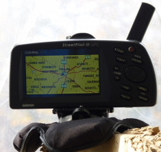
Garmin Street Pilot III pentru activitati outdoor, barca sau offroad (protejat la apa, etc)
-
Produs:Second Hand, Fără garanție
-
Numar articol:138421791
-
Disponibilitate:Indisponibil
-
Preț:250,00 Lei
-
Anuntul a expirat la:10.02.2014, 13:59
-
Ai o nelamurire?
-
Vandut de:
-
Vinde si tu:Pune in vanzare un produs ca acesta
-
Optiuni:
-
Nu ai gasit ce cautai?
Descriere
Vânzatorul este direct răspunzator pentru produsul afișat în această pagină.
Disponibilitate: Indisponibil - Vezi produse similare
Specificatii
Livrez aparatul insotit doar de sportul de bord original si orientabil. Atat. Functioneaza cu 6 baterii AA sau acumulatori AA . Are harta europei, insa romania doar la nivel de strazi principale (sosele centura, bulevarde, strazi principale), insa daca va veti confectiona cablu de date, veti putea instala harta detliata, dar si harta pt outdoor/offroad (am si eu).
Sper sa fie evident pentru oricine ca "dungile" de pe imagine sunt datorate ratei de refresh a lcd-ului, ele nu-s asa decat in poza (ma refer la pozele mele, nu la cele de pe situl de prezentare de mai jos)
Link util : gpsinformation.net/spiii/sp3review.htm
Detalii mai jos:
Features:

- Suited to be installed in any kind of vehicles. Dash mount kit with adhesive folie and shutter for quick mounting and dismounting to easily remove the GPS receiver (seamless switching between cars, theft protection etc.).
- Water resistant up to approx. 3 feet (1 meter) for about 30 minutes (conforms to IPX7)
- Large, illuminated, easy to read LCD display: 3.75" diagonal (9.5 cm), resolution: 240x128 pixel, 16 colors
- Manual or automatic switching of the display between daytime and nighttime, based on time and the current position (changes the colors of the display between sunset and sunrise for more comfortable viewing) Daytime: bright background, nighttime: dark background.
- User interface in English.
- Integrated world map (overview) with countries of all continents including major cities
- Integrated, detailed maps of Europe, Africa and the near East with countries, waters, towns, highways, major roads and city maps. Navigational information are available for the following countries: country list
- Slot for additional memory module to download
additional, even more detailed maps with roads, crossings and
addresses of restaurants, public buildings, points of interest etc.
from a PC.
(Memory modules are available as an option) - Integrated 12 channel receiver with adjustable, very sensitive built-in antenna
- Powered by 6 AA batteries (last up to 16 h with grayscale display or up to 9 h with color display) or by an external 12 V power source, e.g. from a car's lighter (power cord included)
- Short time to first fix (TTFF¹: approx. 15 seconds after a warm start, meaning there are valid coordinates of the satellites available, or approx. 45 seconds after a cold start, meaning there are no valid coordinates of the satellites available)
- Supports the following protocols for data exchange with PC: NMEA 0183 with 4800 Baud, GARMIN, GARMIN DGPS, Text, RTCM IN, RTCM/NMEA and RTCM/TEXT
- DGPS (Differential GPS) ready (GARMIN differential receiver available as an option)
- Supports more than 100 different datum (coordinate systems)
- Supports various display formats include the Swiss Grid
- Memory gauge
- Firmware stored in Flash-Memory, can be updated by the user
- Operating temperatures -15 .. 70°C (5° .. 158°F)
- Serial interface RS-232 (connection cable included)
- Dimensions: 173x81x65 mm (6.8x3.2x2.6 inches)
- Weight: 500 g (1.1 pounds, without batteries)
¹) TTFF: Time To First Fix, time until the first information about the local position is acquired.
Information for navigation:
- Information about the position of the GPS satellites and about the quality of the signals
- World map with zoom function in the range of 1200 km to 30 m (800 mi to 120 ft)
- Information on the map displayed in 5 levels of details
- Distance measuring (direct distance)
- Find waypoints, cities and exits
- Extended search function for points of interest, addresses and intersections, if there is a MapSource map available in memory. These maps require an optional memory module, a Windows PC plus a connection cable and are available as options, see MapSource MetroGuide.
- Stores up to 500 waypoints with name (up to 10 characters), icon (choice of 50 symbols), coordinates and altitude
- Stores up to 50 routes with up to 50 waypoints per route with a maximum of 500 waypoints in total. Shows the current position in relation to these waypoints (direction and distance)
- Current position (longitude, latitude, altitude)
- Current accuracy of the position information
- Current time and date
- Current bearing
- Current, average and maximum speed
- Trip duration and distance (Odometer)
- Stores 10 travelled routes (Tracks)
- Time of sunrise and sunset, moonrise and moonset, current phase of the moon, constellation sun-earth-moon
- Supports metric, nautical and U.S. units
Modalitati de livrare si plata
LIVRARE
In Bucuresti
-
- Predare personala in max. 3 zile lucratoare
-
Ramane la latitudinea mea,in functie de user si calificativele pe care le are,daca in anumite cazuri voi fi dispus a trimte prin servicii de curierR
PLATA
- - La predare
Politica de retur
- - Produsul nu se poate returna.


