
John Muir Trail


Descriere
Raporteaza produsVânzatorul este direct răspunzator pentru produsul afișat în această pagină.
Specificatii
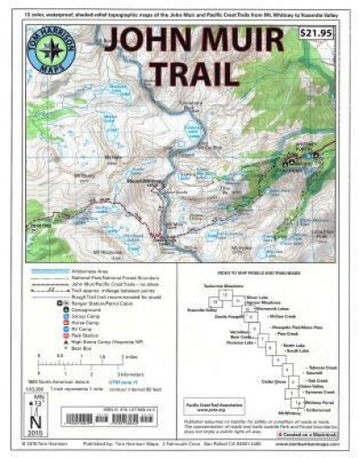
Shaded Relief Topo Maps packet of the famous Sierra High Route that will take hikers from Mount Whitney to Yosemite, CA. Well marked trails over USGS topo maps that were beautifully enhanced with shaded relief to better distinguish details. Scale 1:630360. 1 inch on map equals 1 mile. Whitney Portal, Symmes Creek, Onion Valley, Oak Creek, Taboose Creek, North and South Lakes, Vermilion, Bear Creek, Florence Lake, Pine Creek, Mono Pass, McGee Creek, Devils Postpile, Mammoth Lakes, Agnew Meadows, Silver Lake, Tuolomne Meadows, and finally the Yosemite Valley. GPS Compatible! - Complete UTM Grid.
Galerie foto

Modalitati de livrare si plata
LIVRARE
In Bucuresti
-
- Prin Curier rapid - 12.9 Lei in max. 11 zile lucratoare
In Romania:
-
- Prin Curier rapid - 12.9 Lei in max. 11 zile lucratoare
PLATA
- - Ramburs
- - Avans
Politica de retur
- - Produsul nu se poate returna.
Nu ai gasit ce cautai?
Instaleaza aplicatia Okazii.ro